Town Boundaries and Gates of Ardee
Documentary sources relating to the development of Ardee are scant, comprising only incidental references in the Dowdall Deeds and the Armagh episcopal registers. Any attempt to reconstruct the development of the town is subsequently complicated and, as such, comments on the pattern and growth of the town can really only be viewed as conjecture.
Town walls are the product of former wars or the threat of war. The town was an outpost of the Pale during the Later Middle Ages and the threat of attack was inherent during this period. The walled town of Ardee does not stand out in its regional context because of its neighbours Kells, Dundalk and Drogheda.

Earliest Records
The earliest record mentioning the town is a writ of 22 April 1358 which recites the seizure of the toll of the town of Athirdee in the County of Louth into the king’s hands because Matilda, wife of Eustace le Poer, who held the toll off the king had aliened the toll for life, without the king’s licence.
In the fourteenth century the process of building defensive walls around the town began. A series of murage grants in the fourteenth and fifteenth centuries suggests that this was a major period of building. The first murage grant for Ardee was where a custom on goods for sale for a term of ten years was put in place, in aid of enclosing the town with a ton wall and paving of the streets. It also recorded that tolls, being taken there for the lord’s other ‘town’ Roche should cease, indicating an association between the town and the castle including the potential that Castleroche might have been walled or possibly that all funds may have been diverted to the castle. Further grants were given in 1379, 1389, 1399 and 1413 until a charter was granted to Ardee ‘in perpetuity’ in 1437, indicating many stages of growth and perhaps repair. Thomas* mentions a three-year pontage (toll levied for the building or repair of the bridge) that was made as early as 1306, suggesting possibly that there may have been earlier murage grants.
Extent of Town Boundaries
Ardee’s defensive walls enclosed a large area of approx. 62 acres. This includes 625 meters of unwalled riverside frontage. The area enclosed is larger than Waterford, Trim and Kells but similar in size to Wexford and Rindown.
Once established, the walls appear to have acted as the bounds of the town until the end of the medieval period, when the extramural suburb of Irish Street was formed to the north of the town. Like Kilmallock on Co Limerick, the town was not wholly built up within its walls but included large undeveloped open spaces within the defended area – perhaps indicating an optimism for future expansion or perhaps a sense of foreboding that extra space would be required for refugees from the surrounding area. Perhaps the undeveloped areas to the east of the town were associated with the Carmelite friary lands which, as referred to above, had disused precincts.
There is uncertainty as to whether the Carmelite friary at the south-eastern corner of the town was originally extra-mural; if so this would have been quite an exposed position because an external property adjacent to the town wall could, if captured, prove to be of grave danger to the town. It may be that the town walls were extended eastwards to incorporate the friary and its associated lands.
It is thought unlikely though that all the ground east of Market Street and Castle was built up in the medieval period, and references in the Armagh diocesan registers to orchards within the town indicate that there were open areas. As discussed above religious houses were a prominent feature of medieval life. Most towns possessed an abbey or friary and it is possible that the town wall of Ardee was extended eastwards for this reason. This might imply a simple plan layout of a linear town astride a through-route with a rectangular, walled enclosure and properties that ran from the street back at the right angle to the street towards the wall.
The Gates of Ardee

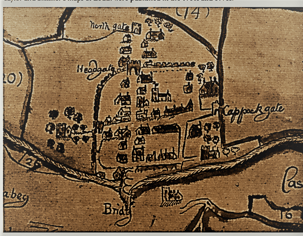
Historic references have indicated that the structural features of the town wall comprised a masonry wall, a fosse/ ditch and a later addition of an earthen defense. The circuit had four gates, on postern (Blind Gate) and one external gate. The earliest detailed depiction of the town is Richardson’s map of 1677 and the sense of enclosure is particularly strong in this image. It indicates that the town had four gates: Bridge Gates to the south: and unnamed gate to the west (which is called Ash Walk Gate), Head Gate to the north and Cappock’s Gate to the east.
A fifth gate, possibly a postern, (often located in a concealed location, allowing the occupants to come and go inconspicuously) on the west side of the town is known from ordnance survey maps and is called Blind Gate. Kenton’s Gate, referred to in 1591, cannot be identified, but it is presumably one of these gates.
Before 1677 Irish Street had been taken into the town and a gate built at its northern end, but it does not appear that the town walls were extended to enclose this street. Richardson’s 1677 map shows an unwalled suburb to the north of the town with its own gate named the ‘North Gate’. The extent of this suburb is likely to have been dictated by the configuration of land ownership within it. The long rear property boundary on the west side of Irish Street suggests the presence of former defences. The North Gate was later referred to as Irish Gate and the name Irish Street and Irish Gate is suggestive of the possibly dispossessed, native population which settled outside the wall. There were many open spaces to the east of the town’s main street. It would appear that the extramural suburb therefore developed in response to the fact that the ‘mere Irish’ were not allowed to own property within the walled circuit.
A possible seventh gate may have been located to the south of Cappock’s Gate where the Avenue cuts through the alignment of the wall. This might be the location of a Fryers Gate mentioned in 1540 and possibly linked to the Carmelite friary which was located in this general area.
The foundation date for the bridge over the River Dee (and Bridge Gate) is not known, but it is first referred to in 1306 when the townsmen were commanded to repair it with stone and lime. Richards map of 1677 shows a three-arched bridge of stone. The present structure is built on the line of the earlier bridge and would appear to be of eighteenth-century construction. It is possible that, like Drogheda, the foundations of an early timer bridge may survive here.
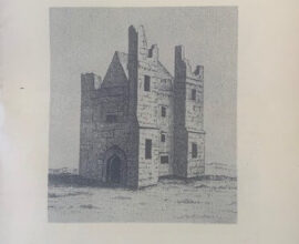
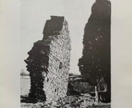
The only undisputed upstanding remnant of the town wall gates is Cappock’s Gate at the eastern end of O’Carroll Street. Two excavations have identified features associated with the town wall at the site of Cappock’s Gate and at the site of the bastion and town wall at Ash Walk Gate.
Taken from County Louth Archaelogical and Historical Journal
References Thomas A (1992) The Walled Towns of Ireland, Bradley J (1984) Ardee, An Archaeological Study